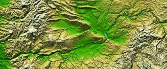
Your Topographic Data of Earth

Bear with us, Top Men are trying to help you get what you've already paid for.
In February 2000 Space Shuttle Endeavour spent 11 days in orbit collecting radar topography using a freaky 200 foot mast that extended out of the cargo bay. The objective of this mission was to map 80% of the Earth's land surface by gathering elevation data points every 100 feet. Each elevation measurement was accurate to within 50 feet.
That's a lot of data; 12.3 terabytes* to be exact. It took a year and a half just to process the data. The total mission cost $142 million USD. The most accurate and complete topographic map of the Earth's surface that has ever been assembled.
And it's all yours. You just have to decide how you want it delivered. Top Men at Wohba can help.
Might we suggest starting with the North American Shaded Relief with Height as Color. It's not a small image (9600 x 7240 - over 50 megabytes for the jpeg), but it's pretty amazing.
If you'd like to zoom in on a particular section of the Earth then you might prefer the USGS Seamless Data Distribution. This is like Google Maps on steroids - which means it big, it's mean, and the results are not always what you'd expect - but when it works it's freakin' amazing! There are lots of options in the frame on the right side of the image. To use the Shuttle Radar Topography Mission (SRTM) data, click on the arrow next to Elevation on the right frame, and check only the box next to SRTM Finished 1 arc sec Shaded Relief.
Explore.
--
* That's 12,300 gigabytes. An iPod with that much storage could hold over 3 million songs. At 3 minutes per song it would play continuously without repeating for over 17 years.


0 Comments:
Post a Comment
<< Home